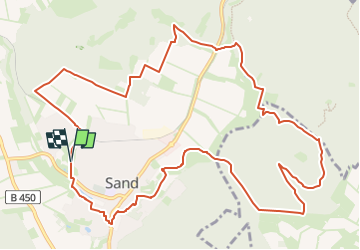
![](/images/other/stat-length.png)
![Excursión A pie Bad Emstal - Habichtswaldsteig - Extratour Bad Emstal - Photo](https://media.geolcdn.com/t/1900/400/ext.pjpeg?maxdim=2&url=https%3A%2F%2Fstatic1.geolcdn.com%2Fsiteimages%2Fupload%2Ffiles%2F1545311037marcheuse_200dpi.jpg)
Habichtswaldsteig - Extratour Bad Emstal
SityTrail - itinéraires balisés pédestres
Tous les sentiers balisés d’Europe GUIDE+
![Longitud](/images/other/stat-length.png)
![Altitud máxima](https://static1.geolcdn.com/siteimages/upload/files/1508320355ic_sort_altitude_max_24dp.png)
![Desnivel positivo](https://static1.geolcdn.com/siteimages/upload/files/1508320355ic_sort_den_pos_24dp.png)
![Km-Effort](/images/other/stat-length.png)
![Altitud mínima](https://static1.geolcdn.com/siteimages/upload/files/1508320355ic_sort_altitude_min_24dp.png)
![Desnivel negativo](https://static1.geolcdn.com/siteimages/upload/files/1508320355ic_sort_den_neg_24dp.png)
![Boucle](https://static1.geolcdn.com/siteimages/upload/files/16400158638029165_repeat_loop_refresh_sync_direction_icon.png)
![A pie](https://static1.geolcdn.com/sitytour/trail-icons/100.png)
3h52
Dificultad : Fácil
![Escanee este código QR para abrir la excursión en la aplicación SityTrail](https://capi.geolives.com/qq0zvz2zws4bq2lad0pu/sitytour/trails/3092369/qr.png?size=200)
Aplicación GPS de excursión GRATIS
A propósito
Ruta A pie de 12,9 km a descubrir en Hesse, Landkreis Kassel, Bad Emstal. Esta ruta ha sido propuesta por SityTrail - itinéraires balisés pédestres.
Descripción
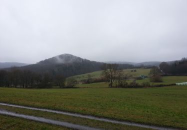
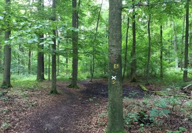
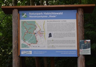
Es ist eine zauberhafte Tour durch satte Wiesentäler und tiefe Naturwälder, entlang an Waldrändern mit weiten Blicken über das Tal der Quellen und das ehemalige Land der Chatten.
Sitio web: https://www.naturpark-habichtswald.de/touren/h6-im-tal-der-quellen
Localización
Comentarios
Excursiones cerca
![Excursión A pie Naumburg - Naumburg-Elbenberg - E3 - Photo](https://media.geolcdn.com/t/375/260/f46b84e6-0b0a-4b9f-bada-5d742549cd4f.jpeg&format=jpg&maxdim=2)
![A pie A pie](https://static1.geolcdn.com/sitytour/trail-icons/100.png)
A pie
![](/images/other/stat-length.png)
![](https://static1.geolcdn.com/siteimages/upload/files/16400158638029165_repeat_loop_refresh_sync_direction_icon.png)
![Excursión A pie Niedenstein - Niedenstein, N3 - Sengelsberg - Photo](https://media.geolcdn.com/t/375/260/4ed4a3a2-bd5e-4fad-8f78-44d080b6d336.jpeg&format=jpg&maxdim=2)
![A pie A pie](https://static1.geolcdn.com/sitytour/trail-icons/100.png)
A pie
![](/images/other/stat-length.png)
![](https://static1.geolcdn.com/siteimages/upload/files/16400158638029165_repeat_loop_refresh_sync_direction_icon.png)
![Excursión A pie Bad Emstal - Rundwanderweg](https://media.geolcdn.com/t/375/260/6152dd1e-c62a-41d9-ac07-c6e6a253257c.jpeg&format=jpg&maxdim=2)
![A pie A pie](https://static1.geolcdn.com/sitytour/trail-icons/100.png)
A pie
![](/images/other/stat-length.png)
![](https://static1.geolcdn.com/siteimages/upload/files/16400158638029165_repeat_loop_refresh_sync_direction_icon.png)
![Excursión A pie Bad Emstal - Naturparkweg 2 - Photo](https://media.geolcdn.com/t/375/260/56644780-7d07-49f2-8524-c7cbbaefe392.jpeg&format=jpg&maxdim=2)
![A pie A pie](https://static1.geolcdn.com/sitytour/trail-icons/100.png)
A pie
![](/images/other/stat-length.png)
![](https://static1.geolcdn.com/siteimages/upload/files/16400158638029165_repeat_loop_refresh_sync_direction_icon.png)
![Excursión A pie Schauenburg - Schauenburg, S4 - Photo](https://media.geolcdn.com/t/375/260/6a77dc7f-f009-4e54-bde5-58b683fb2794.jpeg&format=jpg&maxdim=2)
![A pie A pie](https://static1.geolcdn.com/sitytour/trail-icons/100.png)
A pie
![](/images/other/stat-length.png)
![](https://static1.geolcdn.com/siteimages/upload/files/16400158638029165_repeat_loop_refresh_sync_direction_icon.png)
![Excursión A pie Schauenburg - Schauenburg-Breitenbach, Rundweg 1 - Photo](https://media.geolcdn.com/t/375/260/032608dc-851a-4041-9641-fe96126ffeaa.jpeg&format=jpg&maxdim=2)
![A pie A pie](https://static1.geolcdn.com/sitytour/trail-icons/100.png)
A pie
![](/images/other/stat-length.png)
![](https://static1.geolcdn.com/siteimages/upload/files/16400158638029165_repeat_loop_refresh_sync_direction_icon.png)
![Excursión A pie Bad Emstal - Schauenburg, S1 - Photo](https://media.geolcdn.com/t/375/260/032608dc-851a-4041-9641-fe96126ffeaa.jpeg&format=jpg&maxdim=2)
![A pie A pie](https://static1.geolcdn.com/sitytour/trail-icons/100.png)
A pie
![](/images/other/stat-length.png)
![](https://static1.geolcdn.com/siteimages/upload/files/16400158638029165_repeat_loop_refresh_sync_direction_icon.png)
![Excursión A pie Schauenburg - Schauenburg, Rundweg 2 - Photo](https://media.geolcdn.com/t/375/260/6a77dc7f-f009-4e54-bde5-58b683fb2794.jpeg&format=jpg&maxdim=2)
![A pie A pie](https://static1.geolcdn.com/sitytour/trail-icons/100.png)
A pie
![](/images/other/stat-length.png)
![](https://static1.geolcdn.com/siteimages/upload/files/16400158638029165_repeat_loop_refresh_sync_direction_icon.png)
![Excursión A pie Niedenstein - Niedenstein, N5 - Rundweg zur Ruine Falkenstein - Photo](https://media.geolcdn.com/t/375/260/4ed4a3a2-bd5e-4fad-8f78-44d080b6d336.jpeg&format=jpg&maxdim=2)
![A pie A pie](https://static1.geolcdn.com/sitytour/trail-icons/100.png)
A pie
![](/images/other/stat-length.png)
![](https://static1.geolcdn.com/siteimages/upload/files/16400158638029165_repeat_loop_refresh_sync_direction_icon.png)